
Peng Chau Island
Peng Chau is separated from Discovery Bay by the sea, with just over 6,000 residents living at a leisurely pace. The topography of the island is similar to the word "concave", with an area of less than 1k㎡, so it will not take a lot of time to visit the whole territory. The Central Ferry Pier and Mui Wo and Discovery Bay on Lantau Island all have boats to Peng Chau Island, with the Central Link being the most frequent and stable.
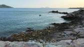
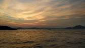
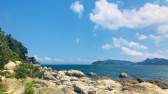
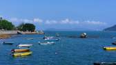
The scenery along the Peng Chau Coastal Road is better than that of Cheung Chau West Dike. After landing, head south along the coast, and the 600-meter coastal road has a pleasant view. Due to the influence of Lantau Island, it is not possible to see the scenery of the water and sky, but the water quality of the outlying islands is good, and the water is blue enough when the weather is clear. Peng Chau Island is not a safe haven, so there is no embankment like Cheung Chau, and there is no beach buffer on this section of the coastal road, and the waves crash directly against the wall, and the sound of the waves can be heard when the wind is calm.
There are benches along the road where you can take a break and watch the sea, and the residential areas in the inland direction also provide a view. Most of the residences are 2-3 storeys, with a neater layout than Cheung Chau, and the walls are also carefully painted. There are green plants in front of every house, and all kinds of boats and boats are placed, which is very pleasant. The proportion of elderly residents in Peng Chau is significantly higher than that of Cheung Chau, and sometimes they will take a walk along the seaway to enjoy the scenery, but they will experience it even more deeply when they go deep into the residential area, and many elderly people are involved in running tea restaurants and ice houses.
At the end of the seaside road is the site of the Victory Ash Kiln Factory, and there are many similar industrial ruins on the island. Only those who are familiar enough with the history of Hong Kong can appreciate the atmosphere, and we recommend going north near the ash kiln site and going deep into the residential area along the Finger Mountain. Although Peng Chau Island is not large, the terrain is not as flat as Cheung Chau, and the village houses are also scattered, which consumes more physical strength to go deep into it, but fortunately, there are flat roads from time to time, so as not to be too tired. The island's mansions are densely packed, and when you look back to the sea, you will find a list of rooftop antennas, which are typical of the islanders, and other islands lack such perspectives, so you might as well stop and take pictures.
There are forks in the road, one leading northwest to the central residential area and the other to Finger Mountain. The altitude of Finger Mountain is only about 100 meters, but the trail is not gentle, so it is best to keep your spirit up and do what you can. There is a viewing pavilion at the top, where you can rest and watch the scenery, and then you can turn back along the same path. It is also possible to take the north-west path to the central villages, although the trail leads past the cemetery, and sensitive visitors are better off turning back. There are tea restaurants and ice houses in the central axis old street in the central district, which is also suitable as the end point of the walking tour.
The Peng Chau hiking trail is mostly in the mountains and forests, which is relatively close to nature, but the view is relatively poor, and some sections of the road are stony and dirt roads, so there is no need to visit when the time is limited. Dali is located in the northwest corner of Peng Chau, which was originally an independent island, but it is connected by more than 100 meters of roads and bridges, so it is more convenient to visit. The Dali Beach reef is about 2,000 square meters, there are many fine broken corals, there are also sea crabs and barnacles inhabiting the reef, and there are also villagers who collect mussels here.
The beach is located on the eastern side of the middle part of the island, has a length of 400 meters and a fair width. The water quality of Tung Wan is good, and the annual average turbidity index is the second highest among the monitoring points on the outlying islands, but it is also the beach with the lowest water temperature, with an average water temperature 2°C lower than that of Pui O. The beach is not sandy and mixed with gravel.
Tips:
1. Visiting Finger Mountain is more tiring, and you can do what you can;
2. When the weather is fine, the seaside embankment has the best view;
3. The beach of Peng Chau Island is average;
4. There are boats between Peng Chau and Central Pier throughout the day, and the frequency is about 40min/shift-60min/shift.
Address: Peng Chau Island, Islands District, Hong Kong