

Nanlang Mountain
The least difficult course is as comfortable as the Family Trail, but it's fun because of its proximity to Ocean Park. Located in the southern part of Hong Kong Island, adjacent to Deep Water Bay, the famous Ocean Park is built around the hilltops of Nam Long Mountain, with a cable car spanning the peaks and connecting the north and south parks. Starting from the Wong Chuk Hang bus stop, continue the climb past the Nam Long Shan Rest Pavilion until you reach the Nam Long Pavilion in the middle of the mountain, where you can overlook the straits around Sham Wan, Ap Lei Chau and Lamma Island. Continuing on, you will reach the helipad, which overlooks the panoramic view of the coast around Deep Water Bay and Repulse Bay, where mountains and rivers meet, and buildings and cars are in full view. At this time, the cable car of Ocean Park shuttles underneath, and you can even hear the shouts of visitors in the park, and the hustle and bustle and tranquility are only a stone's throw away. There are many side roads on this route, but the scenery is similar everywhere, and there is a transmission tower on the top of the hill that affects the view, so it is generally recommended to return the same way.
Recommended Attractions:
Nanlang Mountain
(Difficulty: 1 star)
Starting point: Wong Chuk Hang Bus Stop
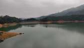
Kowloon Reservoir
Kowloon Reservoir is located in Kam Shan Country Park, and there are many routes with varying degrees of difficulty, this route involves less difficult trails, but can enjoy the scenery of the four reservoirs, which is suitable for beginners. After getting off at Shek Libei Reservoir Station, walk on the side of Changyuan Road, at this time, you can see many monkeys gathered on both sides, but do not feed food and body contact. After passing the Kowloon Sub-Reservoir Dam, keep left and walk around the reservoir to the opening to see the rippling blue waters of the reservoir. Follow the trail up the hill to the embankment of Shilibei Reservoir, where the green lake and the babbling mountain stream are accompanied, and the reflection of Lion Rock on the water surface can be seen in the distance. Finally, find the cement road next to the water lock house downhill, take Kam Shan Road and turn right back to Tai Po Road.
Note: The weather in Hong Kong is changeable, and the route and terrain change greatly, so you need to plan your itinerary in advance before departure, including entrances, exits, and retreats. At the same time, bring all the necessary tools and sufficient dry food and drinking water; Try to go with an experienced hiker; Stay calm when in danger, use a flashlight or whistle to signal for distress if necessary, and use indicators such as marker posts to provide rescuers with the exact location.
Recommended Attractions:
Kowloon Reservoir
(Difficulty: 1 star)
Starting point: Shilibei Reservoir Station
Violet Mountain
Violet Hill is located in Tai Tam Country Park on Hong Kong Island, between Mount Jardine in the north and Mount Jardine's in the south. The mountain is called Violet, but it blooms from April to May in April and May, and its petals are violet-colored, so the mountain gets its name. Take the bus and get off at Wong Nai Chung Park Station, enter Wong Nai Chung Reservoir, walk along the embankment to the end, and walk a short distance to select the "Violet Trail" at the interchange. The trail winds its way up the ridge to the top of Violet Peak, where you can see Wan Chai and Kowloon on a fine day. Head to the aqueduct of the Violet Mountain Trail and descend the stairs to the lush greenery on both sides of the hill with beautiful scenery. When you arrive at Zigang Bridge, you can find that there are two routes, namely the retreat road to Repulse Bay and the branch road to Stanley Gorge Road. If you decide to go forward, you can climb the mountain with a slight slope at the beginning and a slower slope at the end, and reach the summit of Mount Maogang with a view of the mountains around Longji in the east, as well as the beautiful Stanley Peninsula as a reward, and finally end the trip at the Stanley West Aqueduct. The scenery around Violet Mountain is beautiful, and at the same time, there is more room for change in the route, and the mountain stream has flowers such as small flowers and irises and hanging bells to add color. It is worth mentioning that do not use your hands to enjoy the flowers, do not pick the flowers, and do not trample on the plants in order to open up the path.
Recommended Attractions:
Violet Mountain
(Difficulty: 1 1/2 stars)
Starting point: Wong Nai Chung Park Station
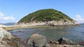
Lamma Island
Lamma Island is the largest island in the Islands District, with its unique natural and cultural ecology, and is only half an hour's boat ride from the Central Ferry Pier, making it a popular choice for tourists from all over the world to visit the islands in Hong Kong. There are two main hiking trails on Lamma Island, one is the "Yung Shue Wan - Sok Kwu Wan" route between the two main piers on the island, this route formulated by the government is part of the Lamma Island Family Trail, on the way through Hung Shing Ye Bay, Lamma Island Power Plant and other scenic spots, the journey is about 1 and a half hours, the up and down is not large, the whole process is a cement trail, the guidance is clear and clear, the scenery along the way is beautiful, you can enjoy the scenery of the two harbors, as well as the former fishing villages and rural customs, suitable for short trips. Another route on the island starts from Sok Kwu Wan and follows the signs next to the Tin Hou Temple to climb up the water chestnut hill and climbs along the ridge to the top of the mountain, with an open view overlooking Sok Kwu Wan and the northern part of Lamma Island, and on a clear day, you can also overlook Stanley, Tai Tam and the mountains of the southern part of Hong Kong Island. After passing the Peak Launch Station, follow the stone steps down the hill, passing through the banana grove and the village houses in turn, and end the tour at Moda Wan (with a street ferry to Aberdeen) or Sok Kwu Wan (with a ferry to Central). This route 2 is slightly more difficult than route 1, but the scenery is also more handsome, and when you climb to the top of the water chestnut peak, you will see the sea and mountain views near Lamma Island. The road is very safe, just keep an eye on the cliff and don't go near the edge.
Recommended Attractions:
Lamma Island
(Difficulty: 1 1/2 stars)
Starting point: Yung Shue Wan; Sokwu Bay
Po Toi Island
Po Toi Island is the southernmost island in Hong Kong and is said to have been named after the futon-like seaweed. Compared with Lamma Island, Po Toi Island has fewer traces of artificial carving, and the beautiful natural scenery has become the main theme. The granite site on the island has poor erosion resistance, and has been weathered for many years to produce all kinds of strange stones, forming scenic spots such as conch stone, monk stone and Buddha hand rock, which is the "top ten most beautiful rocks in Hong Kong" in the minds of many Hong Kong people. Take the ferry from Aberdeen to Po Toi Island Pier, from the pier to the shore, follow the picnic trail next to the shop to the climbing steps, the path slowly ascends, and you can get a glimpse of the first appearance of the bay and the craggy rocks at the opening. In addition to the main path, Po Toi Island also has famous attractions such as "Wu's Ancient Residence" and "Coffin Stone", if time permits, you may wish to follow the street signs to visit. Along the ridge to the Sun Pavilion at the top of Niu Hu, the southernmost view of Hong Kong is refreshing. Continue to move forward, the mountain is slightly downward, arrive at the intersection of Nanjiao Tsui Road and continue to go up the mountain, come to the monk stone, the spirit turtle up the mountain and the Buddha Hand Rock scenic spot, the huge body of the "spirit turtle" is slowly climbing to the top of the mountain, and the "monk" with a slender body on the opposite side bows slightly to the visitors. If you do not go to South Point Tsui, you can return to the pier at Ngong Chuan Junction on the right side, which shortens the journey by about 40 minutes. Po Toi Island is lined with rocks on both sides of the main path, and the beautiful scenery of the rocks dissolving in the clear water is rare elsewhere, and you can finally buy specialty products such as seaweed and dried seafood at the shops along the pier.
Recommended Attractions:
Po Toi Island
(Difficulty: 1 1/2 stars)
Starting point: Po Toi Island Jetty
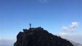
Dragon's Back
Probably the most well-known hiking trail in Hong Kong, it was named the "Best Urban Hiking Trail" in Asia by Time Magazine. Lung Ji is located in the 8th section of Hong Kong Island Trail, and the proximity to the urban area and the beautiful sea view of the Blue Tong area are perfect, so it is no wonder that it attracts tourists from all walks of life. To visit Longji, it is generally recommended to take a bus and get off at Tu Wan Station, board the trail to the top of Ta Rang Cheng Mountain, and you can see the scenery of Shek O and Big Wave Bay when you go up along the ridge. As for the Longji Observation Deck, you can enjoy the 360-degree sea view, the turquoise water is connected with the clear sky, and the beach of Shek O and Big Wave Bay at the foot of the mountain is full of tourists, which is very pleasant. In the right weather, you can also see paragliders hovering like goshawks in the sky, which adds to the fun. The middle and late sections of the route are a little dull, and the downhill road is mostly winding between the trees, but fortunately, the difficulty is not high, and children should be able to cope with it. Descend to the fork next to the Ma Tong Pass Aqueduct, turn right towards Big Wave Bay, and go straight through Collinson Road to the highway. The essence of this route is undoubtedly at the top of Longji Mountain, if you want to make the itinerary more exciting, you may wish to choose the direction of Dalang Bay as the starting point and Land Bay as the end point. The duration of this course is about 1 hour, but it can add to the sense of accomplishment when you reach the top of the mountain, and revel in the beautiful scenery of the sea and sky.
Recommended Attractions:
Dragon's Back
(Difficulty: 2 stars)
Starting point: Land Bay Station
Devil's Mountain
Devil's Hill, also known as Fortress Hill, is located north of Lei Yue Mun and has important military strategic value in the last century because it overlooks the eastern waterway of Victoria Harbour. The British troops stationed in Hong Kong once erected a fort here and got its name. The military installations have been demolished, but only the remains of the city have added to the fun of this urban hiking route. Exit at MTR Yau Tong Station Exit A2, start your journey at Ko Chiu Road, pass through the Lei Yue Mun Estate Car Park and the Chinese Permanent Cemetery, and enter the Wayne Trail Section 3. After the tour, return to the hill and reach the larger Peak Bunker, where you can see the eastern straits of Victoria Harbour, such as Lei Yue Mun, Blue Tong Channel and Fo Tong Mun. Then return to the Wilsin Trail, which follows the mountain to a three-way junction where there is a road to the pavilion at the top of Maohu Mountain. On the way down the mountain, you can see the tall buildings of Tseung Kwan O and another blockhouse, which was once used as an observatory by the so-called "Maowu Abandoned Fort". Descend the stairs and walk towards Lingshi Hospital at Po Lam South Road to end the trip. The route is not very difficult, the start and end point are close to the city, and it includes the remains of bunkers and mountain scenery, which is quite fun. It should be noted that there are many side roads in the route, so it is recommended to check the route and bring a compass in advance.
Recommended Attractions:
Devil's Mountain
(Difficulty: 2 stars)
starting point; Yau Tong Station A2
Tung Ping Chau
This small island in the northeastern corner of Hong Kong is composed entirely of sedimentary rocks, shaped like a crescent moon, and has a flat terrain, hence its name. Tung Ping Chau is Hong Kong's fourth marine park, and its varied coastal landforms have been designated as a UNESCO Global Geopark, and its colorful shale rocks are also known as one of the "Four Natural Wonders of Hong Kong". There is a picnic trail on the island, so if you want to avoid the crowds, it is recommended to start in the opposite direction: when you reach the pier, go right, go around Tai Tong Bay, and walk to the shore to see shale eroded by the waves, rocks weathered to a checkerboard along the crevasses, and stromatolites made of blue-green algae fossils. As the beach reaches the end of the island, the rocks on the shore here are light brown, like rusty iron; Continue past Maogong Cave and Chau Mei Kok, the northernmost part of Tung Ping Chau, and turn the corner to connect to the mud path. Walk through the woods to the Neckless Island Observation Deck, where the rocks on the shore dissolve in a pool of clear water, and on a clear summer day, you can see the Snake Tip and Ma On Shan in the distance. Walking along the path to the rocky beach, a natural draw runs through the north and south, and this mountain mouth, which was originally connected to the island, has been broken due to weathering and erosion, forming a natural corridor connecting the north and south, as if it has been cut vertically, hence the name "Chopping Neck Continent". Then walk back to the hiking trail and cross the trail to the seashore where the rock formations are intertwined, and the jagged rock formations are like dragon's spine diving into the sea, so it is called "dragon falling overboard". Continuing the hiking trail, two rocks are stacked on top of each other along the flat sea, which is a popular photo spot called "Sad-roo-ki", which has several recesses along the coastline to the west of the rock-changing rocks, and the headland behind it is called "sad water" because the water level will submerge the stones at high tide. Then walk along the coast to the westernmost corner of Mazui, and return to the pier through Yama Bay. The whole journey of Tung Ping Chau is not difficult, and there are strange stones to appreciate, it is a route that many local hiking enthusiasts want to explore, that is, its location is remote, there are few routes, tourists only take the ferry to Ma Liu Shui on Saturdays, Sundays and public holidays, the only return flight departs at 5:15 p.m., if you miss it, you need to spend the night on the island, please pay attention.
Recommended Attractions:
Tung Ping Chau
(Difficulty: 2 stars)
Starting point: Dong Ping Chau Wharf